Bayesian methods of data analysis
Bayesian methods are used in the analysis of evidence and the more
standard analysis of data. In the latter we have been examining the
Maxent method.
Trawl tomography
- We have been investigating an alternative to the Maxent method of
modelling fish density distributions. We assume the fish are in
schools of finite dimensions and try to determine the position and
size using a bayesian tomographic method. It is possible to detect
more than one school. Descriptions of the S-PLUS functions are in
thetechnical note S-PLUS code for Estimating
fish concentrations using trawl data
- Further work, still ongoing, into developments of the simple model
is reported in Estimating fish
concentration and location using trawl data with proportional
errors. In this work, errors are assumed to be proportional to the
size of the catch.
- Jackie Honeysett and I are also examining the use of Fourier
series to model fish concentrations using the trawl data. This work
currently uses ordinary frequentist statistical methods.
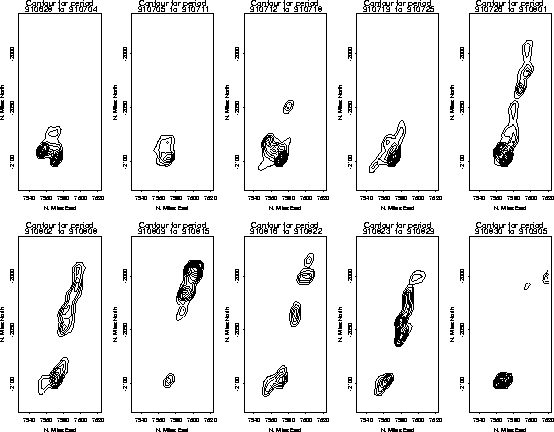
The following diagram shows contour plots of the density of
hoki for a sequence of weeks through the 1991 fishing season,
as extracted by our method.
Publications
MaxEnt Methods
The MaxEnt, or Maximum Entropy, methods of assigning prior
distributions in bayesian methods were introduced by Jaynes. His
approach to probability is set out in his book Probability
theory - The Logic of Science.
We have been using maxent in using information from random commercial
trawls to determine the spacial density of
hoki fish schools in the seas off the West Coast of New
Zealand. Suzette Lizamore has completed an MSc thesis including an
analysis of this problem. It was presented as a paper
(postscript, 602K) to the 1995 Maxent Workshop in Santa Fe
Image Analysis
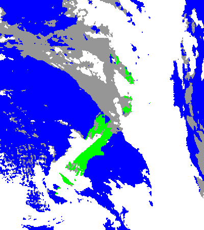
Bevan Flack's MSc thesis topic is combining images from several
satellites to make use of all the data in their detector channels to
distinguish sea and land and high and low cloud. The satellites used
are both geostationary and polar-orbiting. The image below is a
picture from two satellites over a very cloudy New Zealand classified
in this way into the four types from a series of satellite
images.
MaxEnt Links
An abstract of our paper to the 1994
maxEnt conference is available. The MaxEnt Conference
abstracts are available and much material on Maxent is kept in Carlos Rodriguez's
page.
Last updated on 1999 May 28